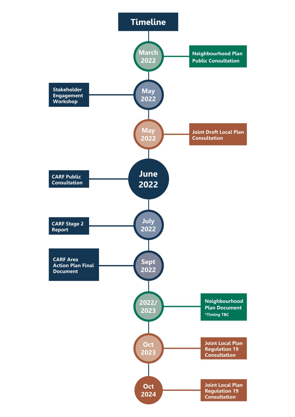
Central Abingdon Regeneration Framework consultation
Vale of White Horse District Council is working with Carter Jonas – an organisation with expertise in regeneration – to help identify parts of Abingdon that have seen better days and consider how they could have brighter futures.
Working together, we held a consultation between 17 June and 15 July 2022 for residents, businesses and visitors alike to give their views on how to help make central Abingdon a thriving place in the future.
The consultation has now closed. However, you can still view all the consultation materials below.
Introduction and Summary
About the CARF
Please click on the image to zoom
“CARF” stands for Central Abingdon Regeneration Framework. The purpose of the CARF is to create a strategy for change in Abingdon town centre to help guide future development, transport projects and interventions over the next 20 years or so. The CARF has a defined study area which includes the historic town centre as well as parts of neighbourhoods immediately surrounding the town centre. The project is being led by Vale of White Horse District Council (VoWHDC) and it is intended that the CARF will be approved by the Council later in 2022. The proposals presented at this exhibition have been informed by local stakeholders.
Other town centre projects are being undertaken at the same time as the CARF. These include the Abingdon Neighbourhood Plan being prepared by Abingdon Town Council and the Joint Local Plan being undertaken by VoWHDC and South Oxfordshire District Council (SODC). The Neighbourhood Plan (NP) will provide a development plan for the area of the town which includes the traditional parish boundary. In addition, VoWHDC and SODC have come together to work on a new Joint Local Plan which will guide new housing and jobs needed in the area, and set planning policy, informing planning application decisions for the districts.
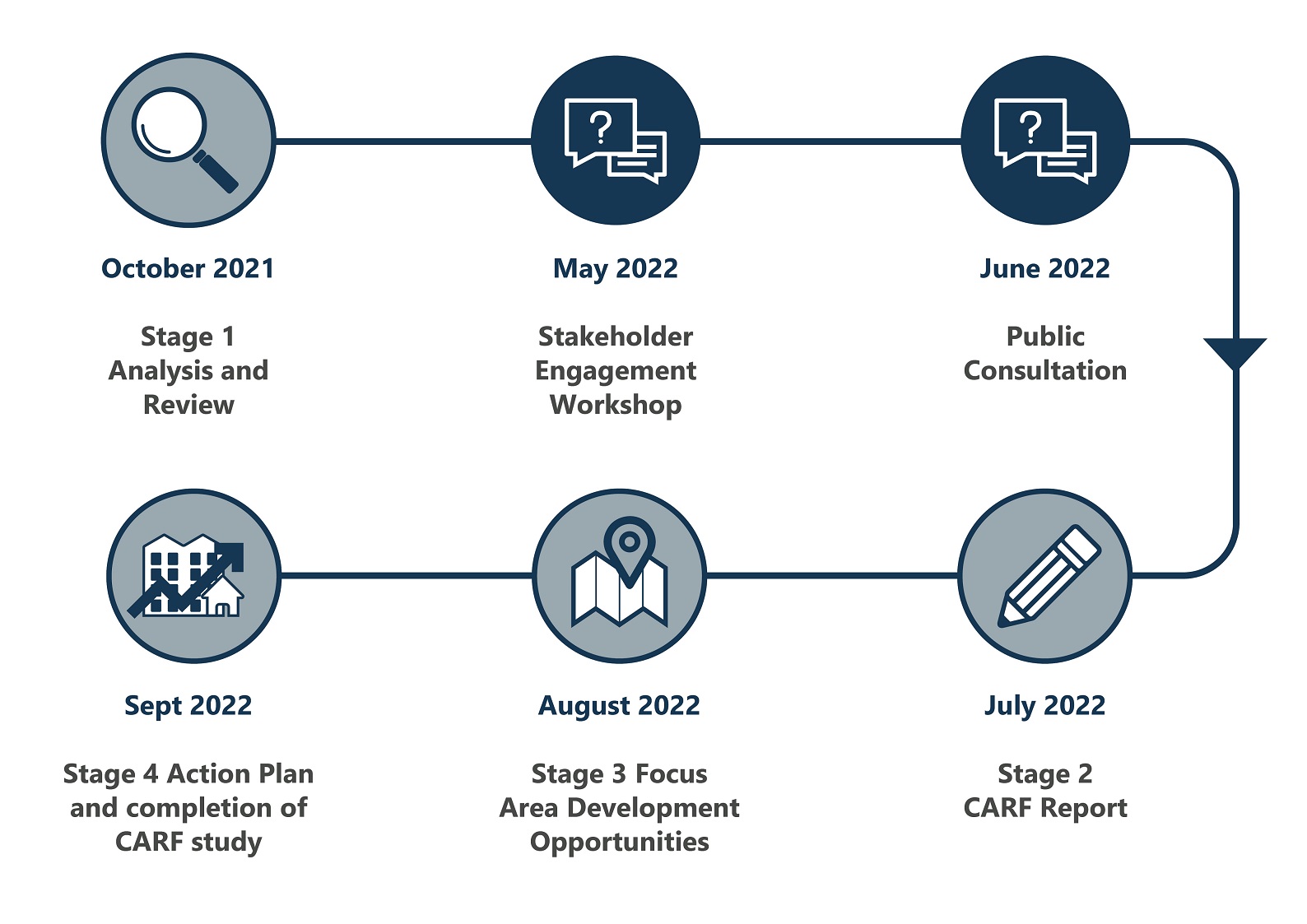
Time frame of Other Studies
The timeline below sets out the key milestones for these projects. At the same time, there are also several transport-focused projects on-going such as the Local Transport and Connectivity Plan (or LTCP) and the ‘Local Cycling and Walking Infrastructure Plan’ (LCWIP), both being led by Oxfordshire County Council (OCC). In addition, Abingdon Carbon Cutters and Abingdon Liveable Streets are preparing their own locally devised LCWIP in the form of the Abingdon Cycling and Walking Network Plan and Sustrans are working on the ‘Abingdon National Cycle Network Missing Link’. Sustrans are an organisation responsible for creating and managing the National Cycle Network, prioritising walking and cycling across the country.
You can continue to explore the consultation materials using the arrows above or the links below.
Privacy Notice: click on this link to read our Privacy Notice
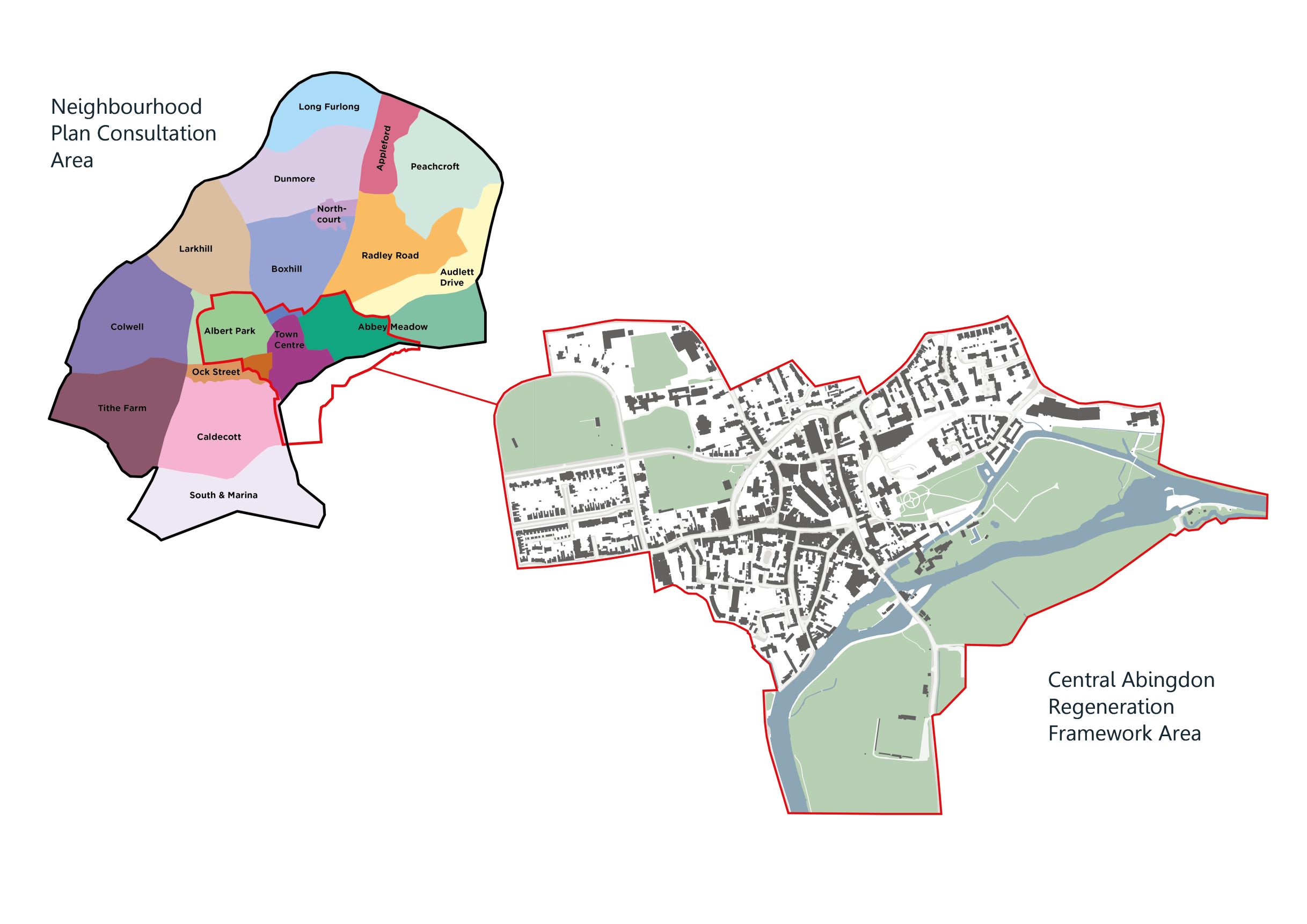
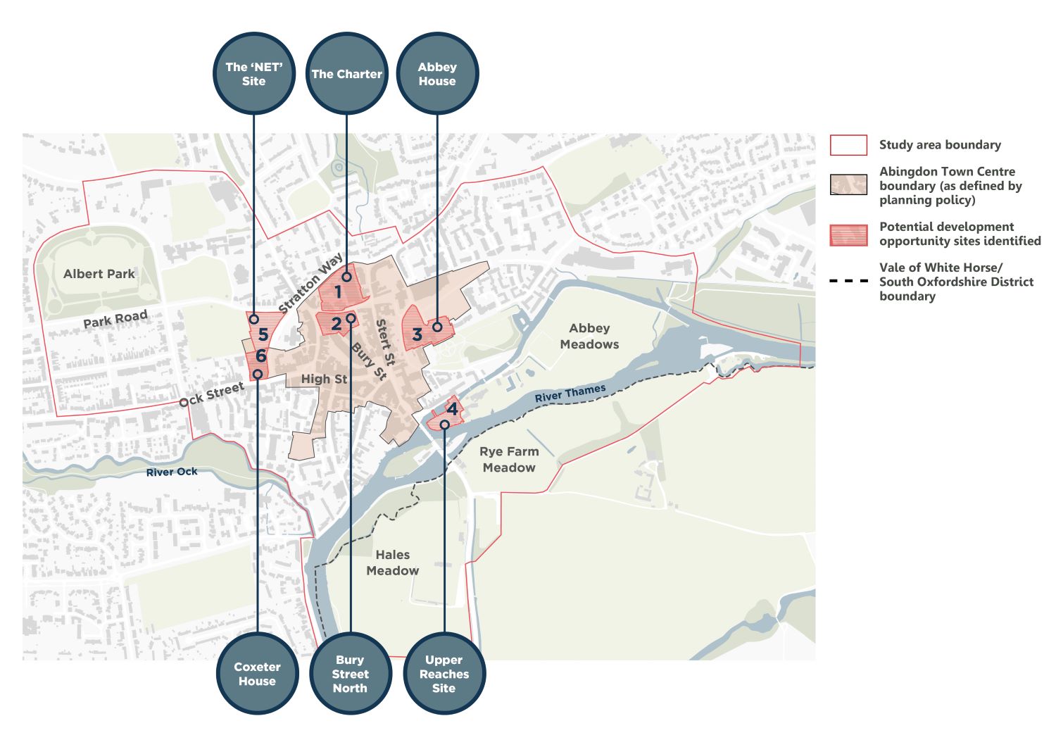
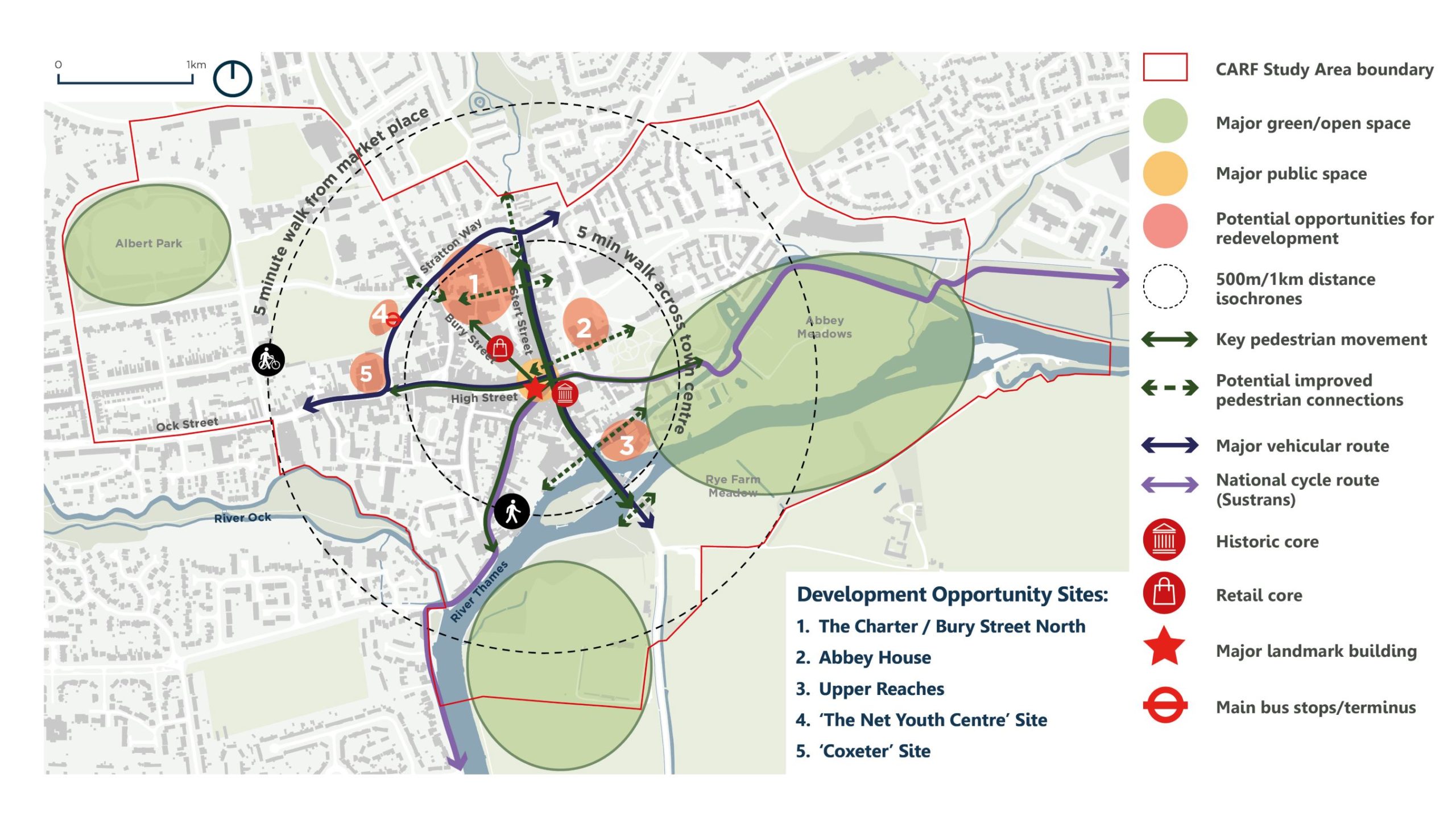
The Study Area
Study Area sites
The CARF covers a 1.13km sq study area around Abingdon town centre. This includes land to the south of the River Thames that lies within South Oxfordshire district.
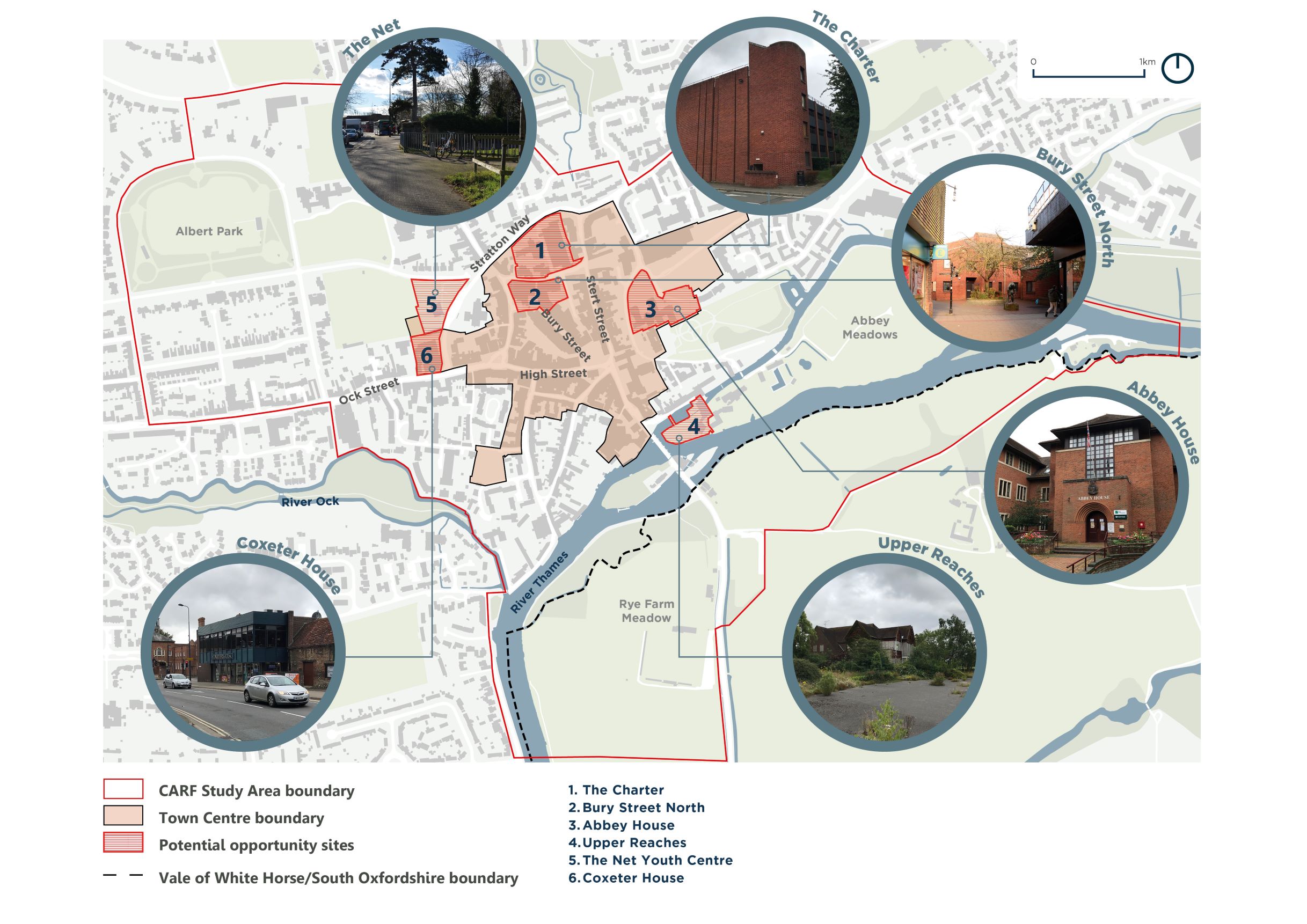
A key part of the study is to look at sites that provide potential opportunities for redevelopment, including three VoWHDC owned sites.
1. The Charter
2. Bury Street North
3. Abbey House
4. Upper Reaches
5. The Net Youth Centre
6. Coxeter House
*Sites outside of VoWHDC ownership
Please click on the image to zoom
You can continue to explore the consultation materials using the arrows above or the links below.
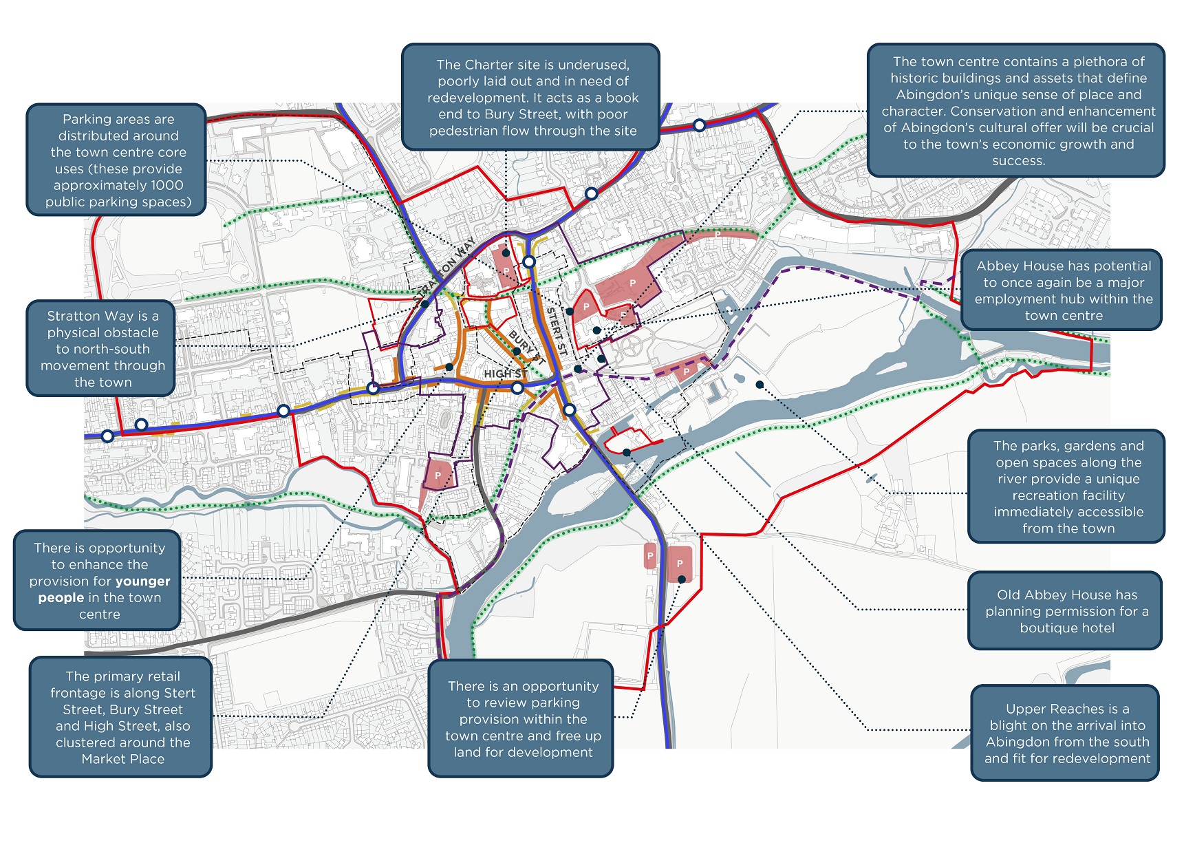
Central Abingdon Analysis
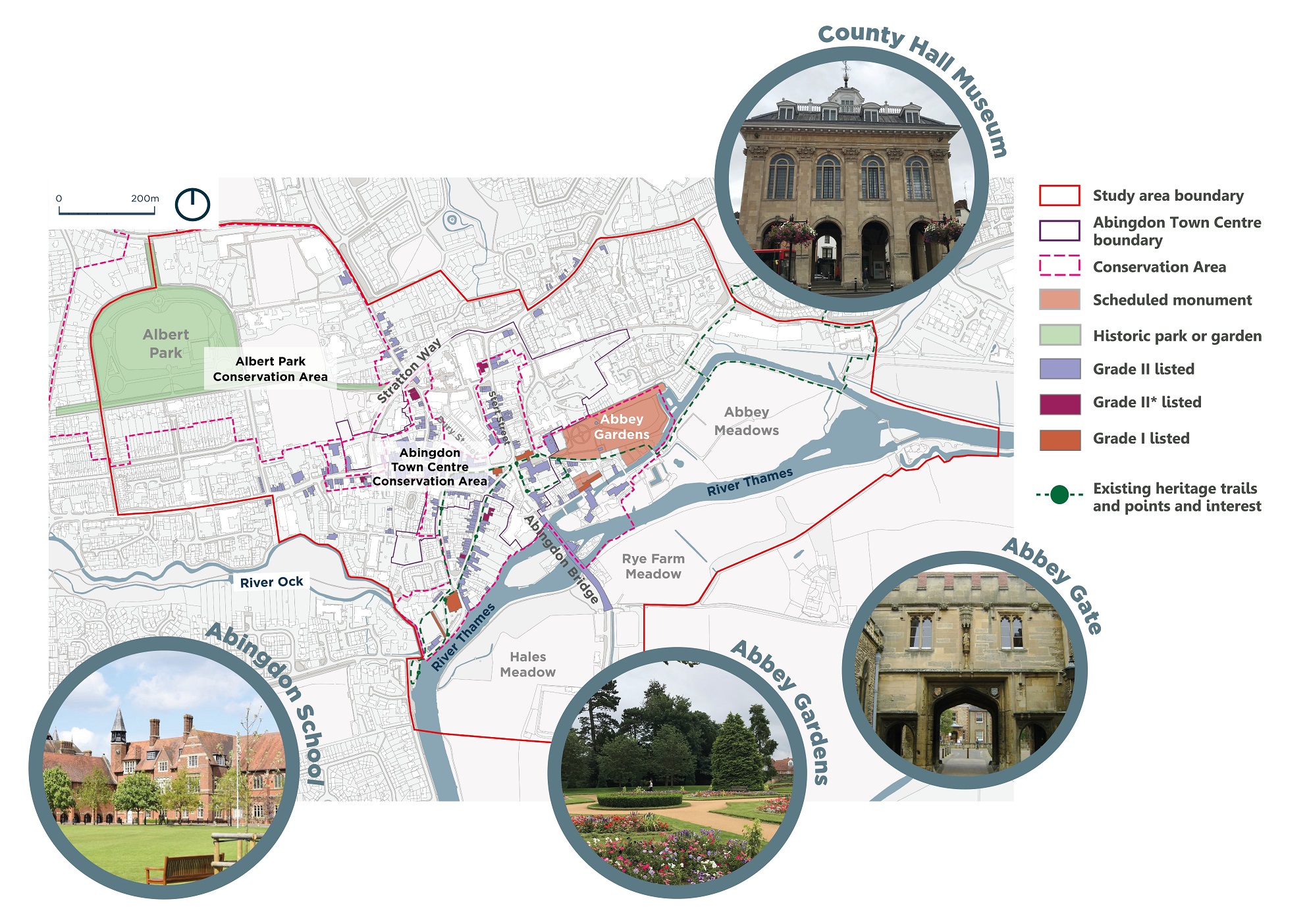
Heritage & Conservation
Historic buildings in Abingdon are predominantly Grade II and Grade II* listed. Old Abbey House is Grade II listed and the gardens are a National Scheduled Monument. There is a Grade II listed building adjacent to The Charter site. Part of the building on the Council owned Upper Reaches site is Grade II listed. The Upper Reaches and Abbey House sites fall within the Abingdon Town Centre Conservation Area. The Charter site lies adjacent to this Conservation Area.
Please click on the image to zoom
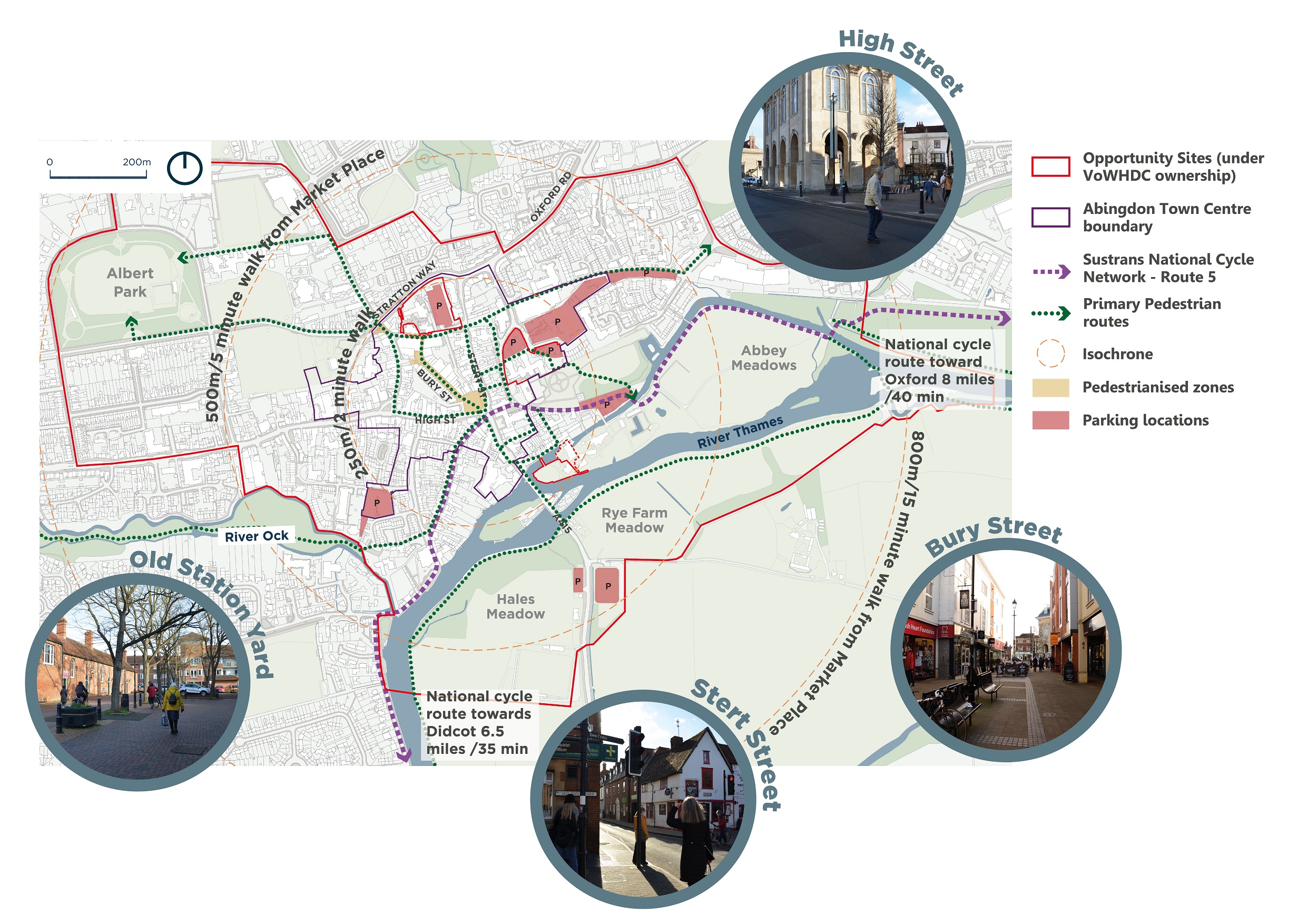
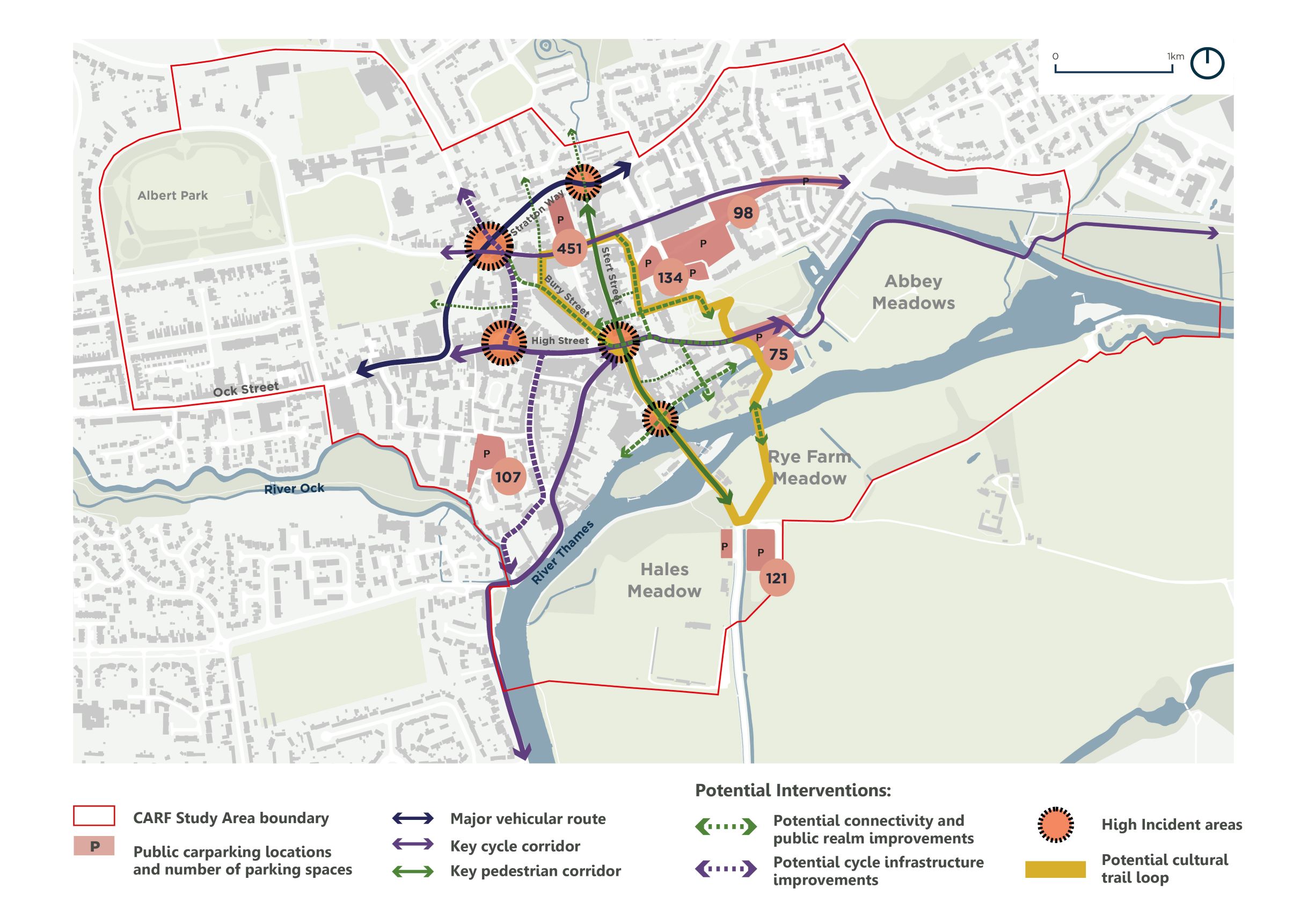
Pedestrian and Cyclist Movement
The plan shows key pedestrian routes and infrastructure within the town centre. Key findings from the CARF Stage 1 analysis have identified Stratton Way as a major barrier restricting movement to the north and west from the town centre, while the junction between Stert Street, High Street and Bridge Street is unsafe for pedestrians and cyclists and could be improved. The LCWIP study found that fully pedestrianised areas are limited in the town centre to Bury Street and Market Place, with the southern part of Bury Street and the area around Market Place benefiting from greater footfall than the northern end.
Please click on the image to zoom
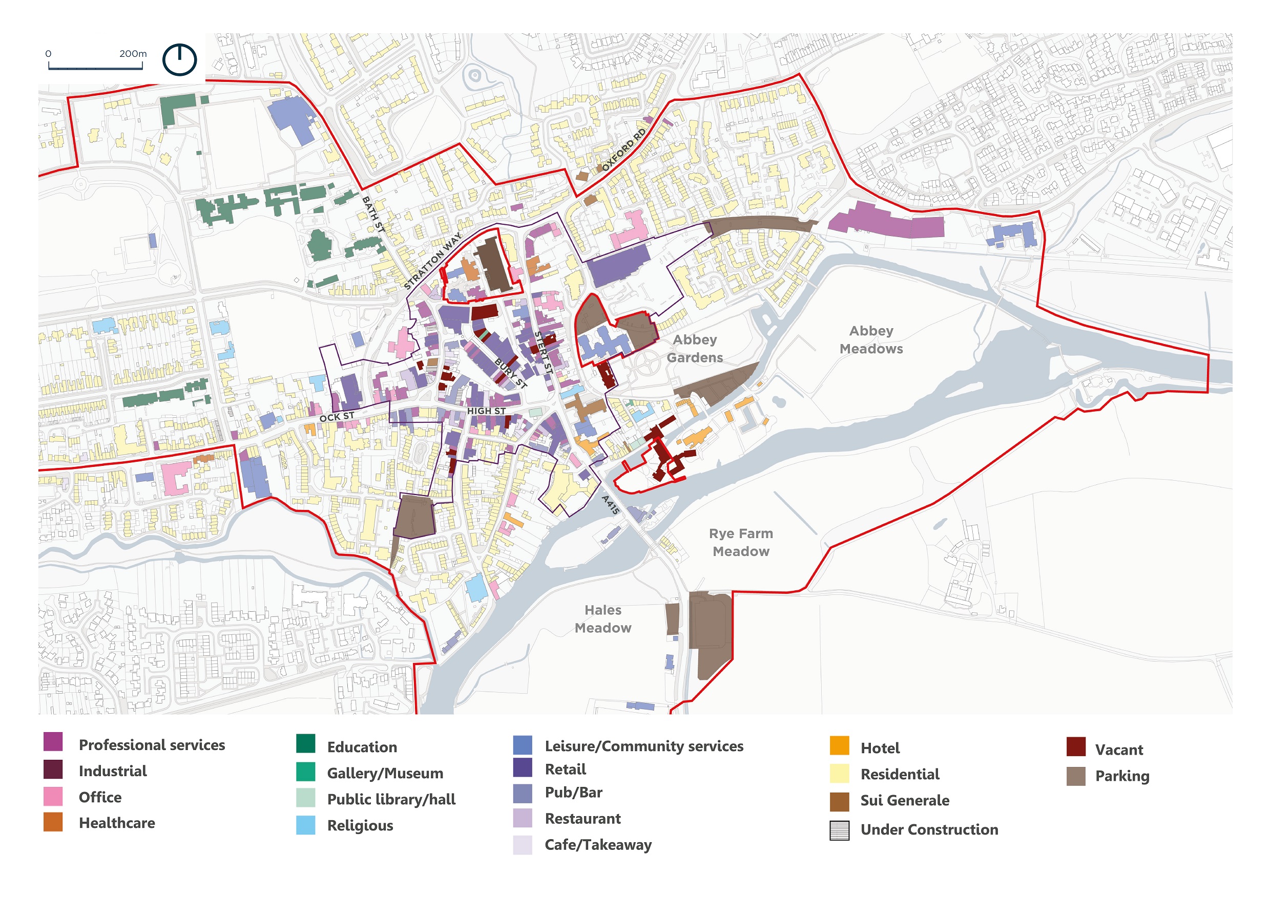
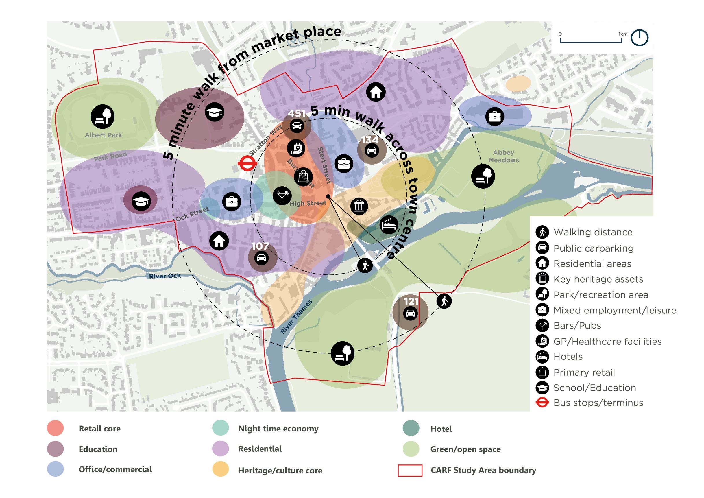
Daytime Land Uses
The map below illustrates the existing land uses within the CARF area. The town centre is dominated by retail led uses, with low rise residential housing around the perimeter and limited residential development within the town centre itself. Several vacant buildings to the north along Stert Street and Bury Street highlight an opportunity to diversify uses in the town centre. This could include new homes, offices and healthcare facilities, building upon the cafe culture and independent retail offering which is popular during the day.
Please click on the image to zoom
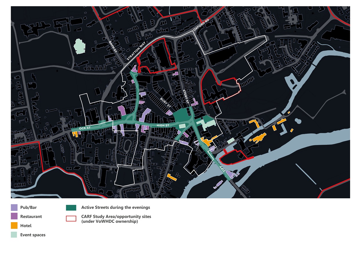
Night-time Uses
The plan illustrates existing land uses within the CARF area that function as part of Abingdon’s night-time and evening economy, and key streets that link these evening uses together. Although there is no dedicated area for these uses in Abingdon town centre, there is a large concentration around High Street/Bath Street. There is potential to build upon this current provision to attract more evening and weekend visitors and place more emphasis on arts and culture as part of what Abingdon has to offer. There may be merit in exploring whether more pubs, bars or restaurants could be located along the river including the Upper Reaches site, to compliment the various hotels that are located around this area.
Please click on the image to zoom
SWOT Analysis Summary
Strengths
• Heritage (but this can also limit the amount of change)
• Attractive riverside setting
• Compact and walkable town centre
• Ample parking provision
• Good bus connections and access to the national cycle network
• Excellent access to green and recreational space
• Strong employment in healthcare, education and retail sectors
• Contained retail core
• Immediate access to key services in under 15 minutes on foot
Weaknesses
• No train station immediately located in the town centre
• Retail and leisure competition from Oxford
• Confusing parking, signage and wayfinding
• Key footfall drivers are located outside of the town centre i.e. schools, retail / leisure uses on Fairacres Retail Park and employment uses on Abingdon Business Park
• One way traffic system / traffic over Abingdon Bridge
• Antisocial behaviour in parts of town centre, e.g. Upper Reaches and The Charter
Opportunities
• Improved library and council services
• Consolidation of car parking
• Diversify the uses within the town centre
• Improved pedestrian safety
• Provision of night-time economy uses
• Reduction of air pollution and response to climate change though provision of new sustainable development and implementation of Electric Vehicle infrastructure in the town centre
• Better connections with existing and proposed communities to the north of Abingdon
Threats
• Heritage (which can limit the amount of change)
• Old Abbey House remains vacant and an under-utilised site.
• Climate change – in particular an increased risk of flooding to the Upper Reaches site
• Over reliance on private car use
Please click on the image to zoom
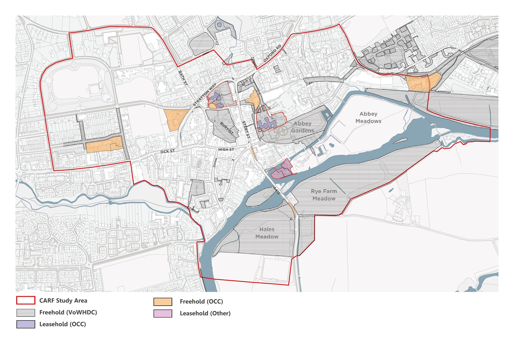
Land Ownership
The plan below shows public sector assets within and around the town centre study area. This includes both public open space and developed sites with a mix of property assets. VoWHDC / OCC owned sites can play a major role in the vision and delivery plan for the town centre, given the desire for their redevelopment and prominence within the town. These sites should not be viewed as development opportunities in isolation, but as part of a broader vision for Abingdon which considers all landholdings within the study area and ensures a comprehensive approach is taken.
Please click on the image to zoom
You can continue to explore the consultation materials using the arrows above or the links below.
Stakeholder Workshop Summary
A workshop was hosted on 4 and 5 May 2022 at Abbey House for local stakeholder groups.
Approximately 40 representatives of various local groups attended and were asked to provide feedback and ideas on various delivery strategy themes that have emerged from the initial analysis and design objectives on this page.
Design Objectives
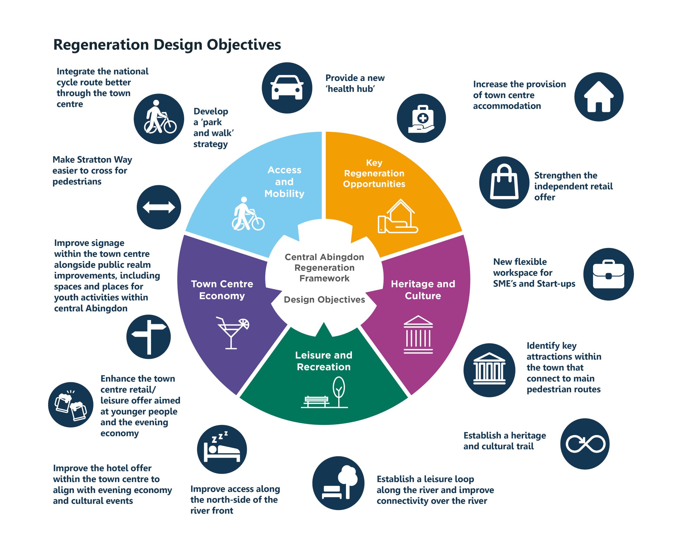
Please click on the image to zoom
Concept framework
Please click on the image to zoom
The stakeholder workshop feedback to these themes is summarised below.
Delivery Strategy 1:
Town Centre Access and Public Realm Improvements
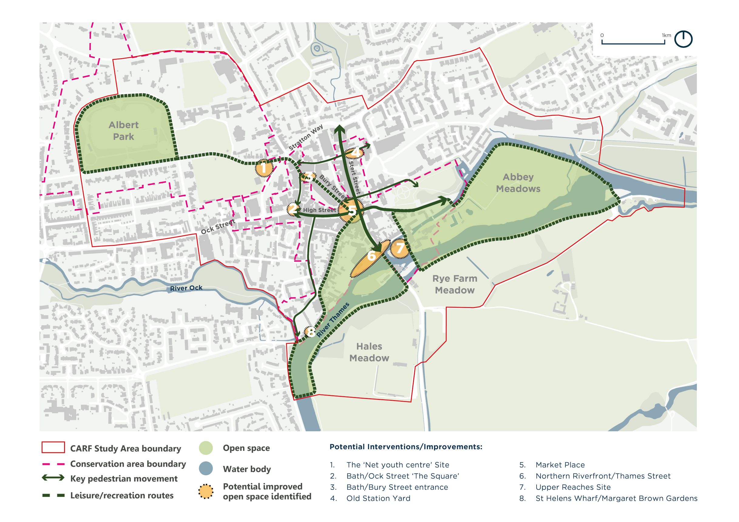
The main comments in relation to this topic were the need for improved pedestrian and cycle facilities in the town centre, especially around the Market Place; the potential for “park and walk” facilities leading into the town centre; better pedestrian links, especially from the south, including the potential for a new pedestrian/cycle bridge across the River Thames; the need for improved bus priority in some locations; and the need to make the town centre more accessible in general for all user groups.
Please click on the image to zoom
Delivery Strategy 2:
River Access and Recreation Provision
Comments raised in relation to this topic included the lack of activities for youth and young adults in the town centre; improved use of, and access to, the River Thames for a variety of river-based activities and leisure; and a greater focus on arts, heritage and culture events and activities including a cultural trail.
Please click on the image to zoom
Delivery Strategy 3:
Land Use Diversification
Stakeholders suggested several strategies for diversifying land use and activity in the town centre including an improved tourist information centre; the creation of a health “hub” to house existing doctor’s surgeries and complimentary health services; re-housing the library; continued support for independent retailers rather than new large format retail; ensuring mixed use with new residential uses; and improving the visitor appeal, potentially including the provision of new hotel accommodation.
Please click on the image to zoom
Delivery Strategy 4:
Key Opportunity Sites
Feedback received on this topic included the need to redevelop The Charter/Bury Street North area due to the appearance of the area and associated anti-social activities, with the potential for an integrated health hub amongst other uses in this location; the long-standing need to redevelop the Upper Reaches site; the benefit of better youth provision in the town centre, including potential re-established facilities at The Net site; and the desire to consider other opportunity sites for potential future re-purposing, including Abbey House.
Please click on the image to zoom
You can continue to explore the consultation materials using the arrows above or the links below.
Vision and Objectives
A Vision for Abingdon
Our Vision for Abingdon town centre is based on key “themes for change” to help foster and create an attractive, lively, dynamic, sustainable and highly functional location for the benefit of residents and visitors alike. The themes are also based on the feedback we have received from local stakeholders.
The key themes for change include:
- Improving access and the public realm of the town centre.
- Re-connecting the town centre to the River Thames and creating improved links and leisure in and around the river and local green spaces.
- A strong economic base for the town centre through a diversified and attractive mix of uses to support working, shopping, living and visiting.
- The redevelopment of key sites within the town centre for uses that serve local need and benefit the town as a whole.
Key Regeneration Objectives
- Protect Abingdon’s rich heritage whilst better promoting the cultural offer;
- Consolidate public parking provision and as a result free up land for development in the town centre;
- Improve walking and cycle links through the town which are currently dominated by vehicles;
- Enhance bus stops/connections and promote use of public transport, including access to Radley Station to reduce reliance on the private car;
- Provide new and co-located healthcare facilities;
- Improve the night-time leisure/hospitality offer by creating more floorspace to promote Abingdon as an evening destination for food, drink and entertainment;
- Foster and promote Abingdon’s daytime independent retail and leisure offer;
- Respond to climate change objectives by cutting down pollution through reduced traffic/air pollution and generate green energy in the town centre through new developments;
- Better connect communities to the north and south of the town with the town centre as part of any improved pedestrian/cycle connections, in particular across Stratton Way and the River Thames which are physical obstacles to movement for some users; and
- Reduce antisocial behaviour, particularly around The Charter and Upper Reaches areas of the town centre, through redevelopment and town centre management.
Key Opportunity Sites
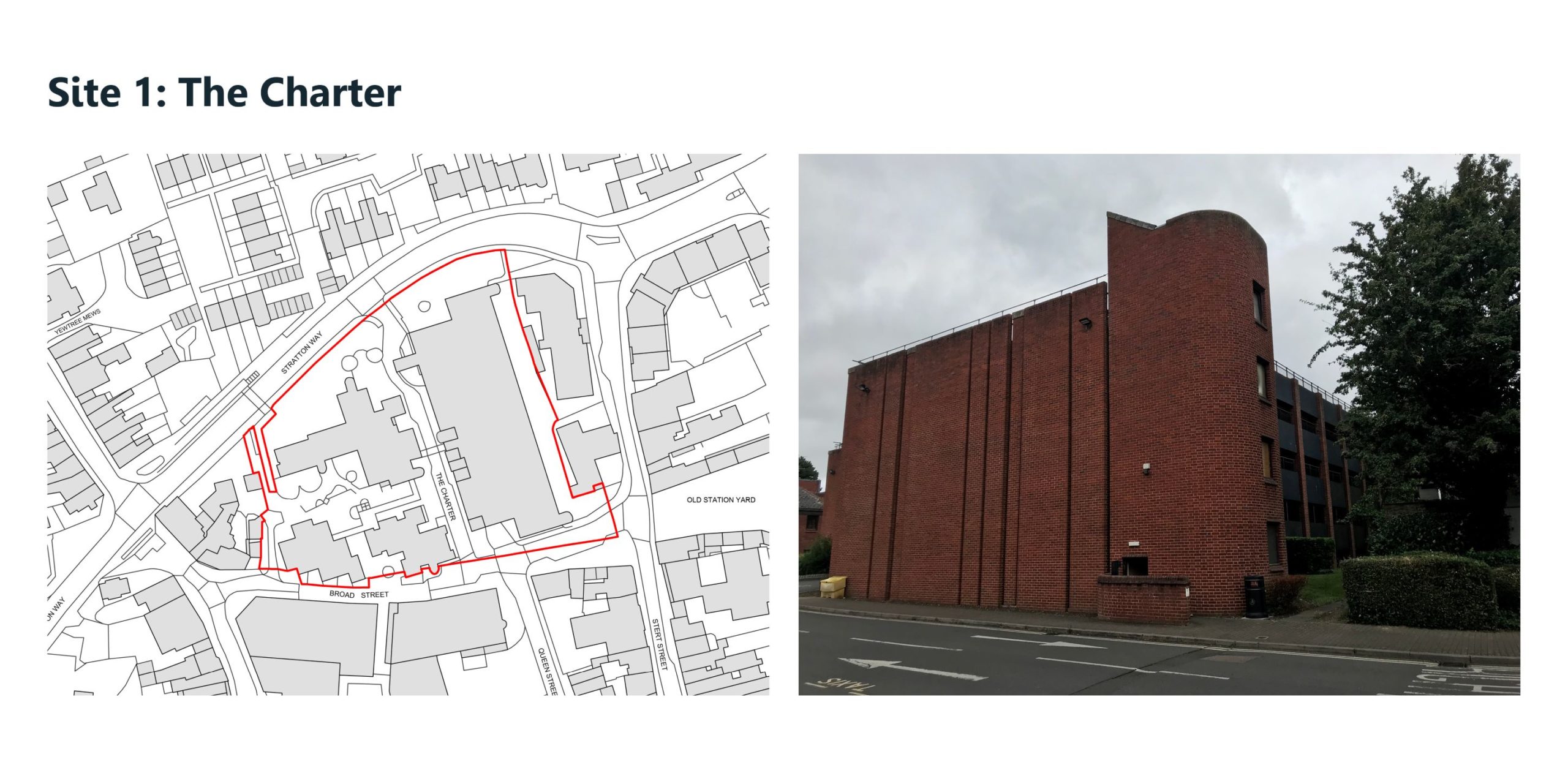
Site 1: The Charter
The Charter area represents an opportunity to remove unattractive, utilitarian buildings housing Abingdon Library facilities, existing Malthouse Surgery and The Charter carpark amongst others, and re-provide them and other uses on-site. This could include a health hub, offices and retail with potential to re-provide some parking on site.
Please click on the image to zoom
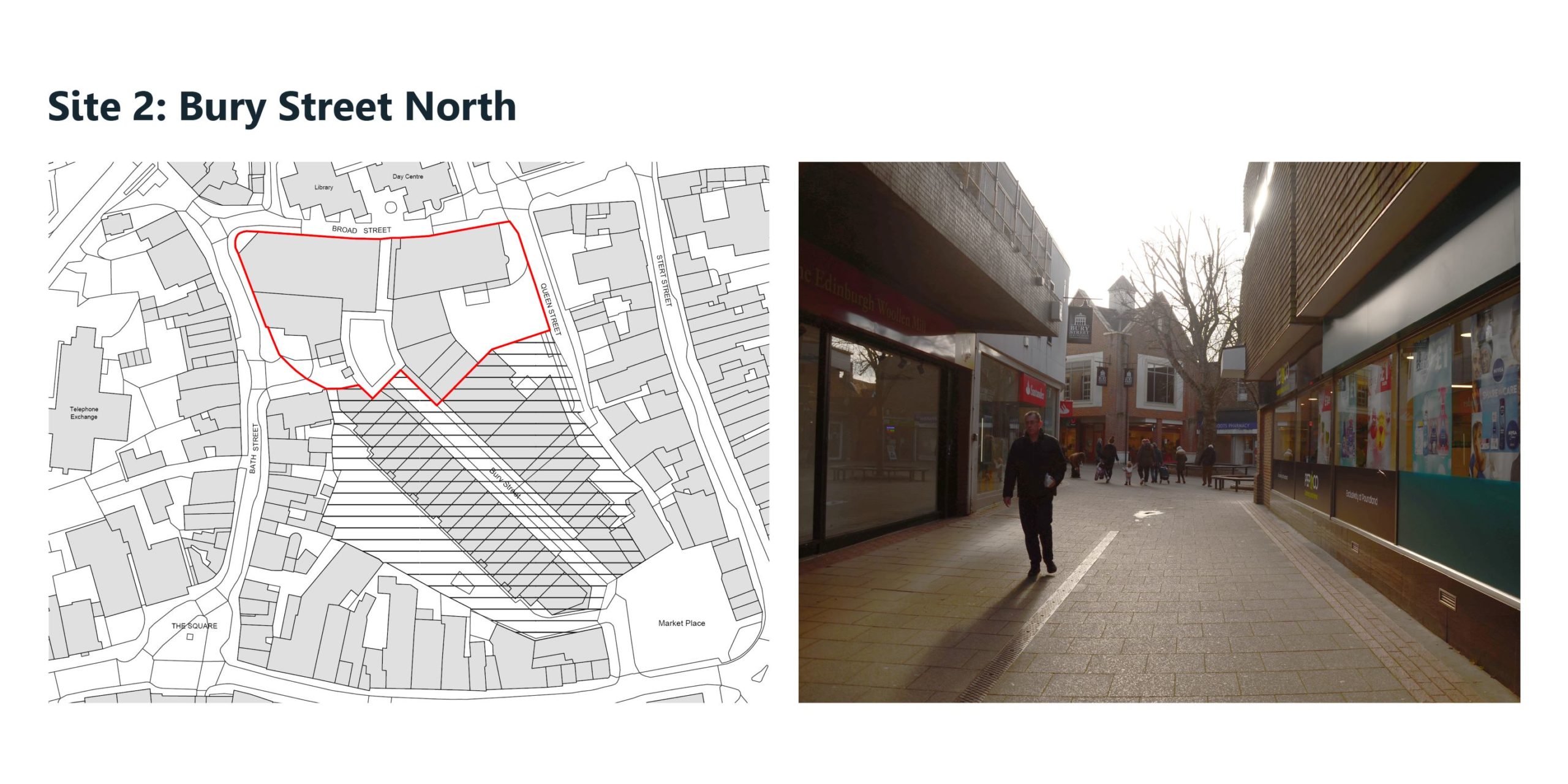
Site 2: Bury Street North
Closely allied with The Charter and ideally delivered in a coordinated fashion, the lower and upper floors of shops along this part of Bury Street could potentially be refurbished. There is also the potential to make better use of the upper storeys through extending ground floor uses upwards or converting to residential use.
Please click on the image to zoom
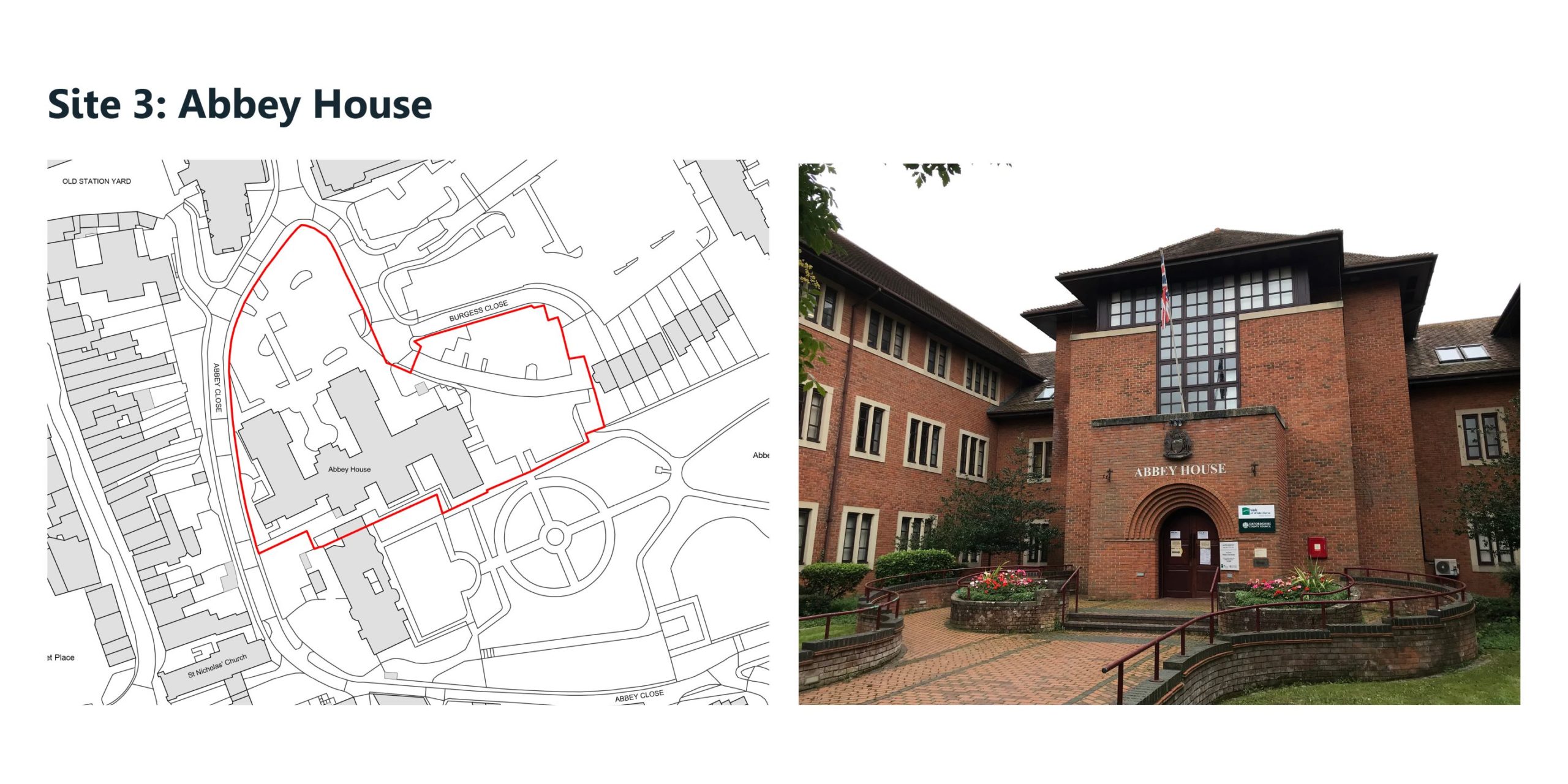
Site 3: Abbey House
Our vision is to refurbish or re-purpose the new Abbey House and associated car parking area to the north-west of the site. This could support uses that contribute positively to the town centre, which may include office space, residential accommodation, a hotel and a health hub. Any change to new Abbey House should complement the refurbishment of Old Abbey House as a hotel. There is also the opportunity to improve the pedestrian connections from Stert Street to the west through the site.
Please click on the image to zoom
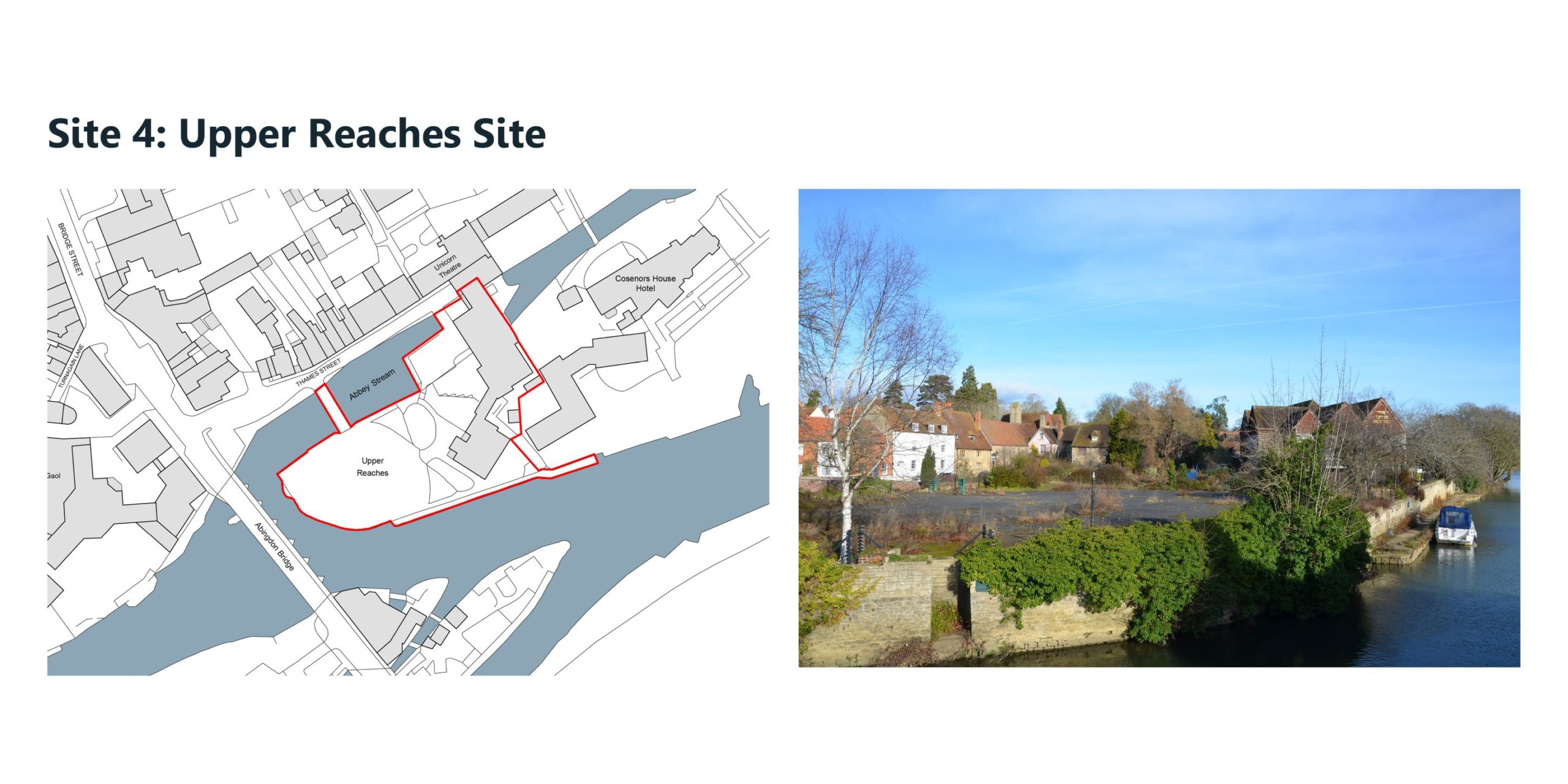
Site 4: Upper Reaches
The site provides the opportunity to re-purpose the Grade II listed building to the north-eastern part of the site, as well as provide complementary recreational open space. There is potential for a future new pedestrian/cycle crossing of the river to be positioned in this vicinity.
Please click on the image to zoom
You can continue to explore the consultation materials using the arrows above or the links below.
Town Centre Movement and Public Realm Potential Proposals
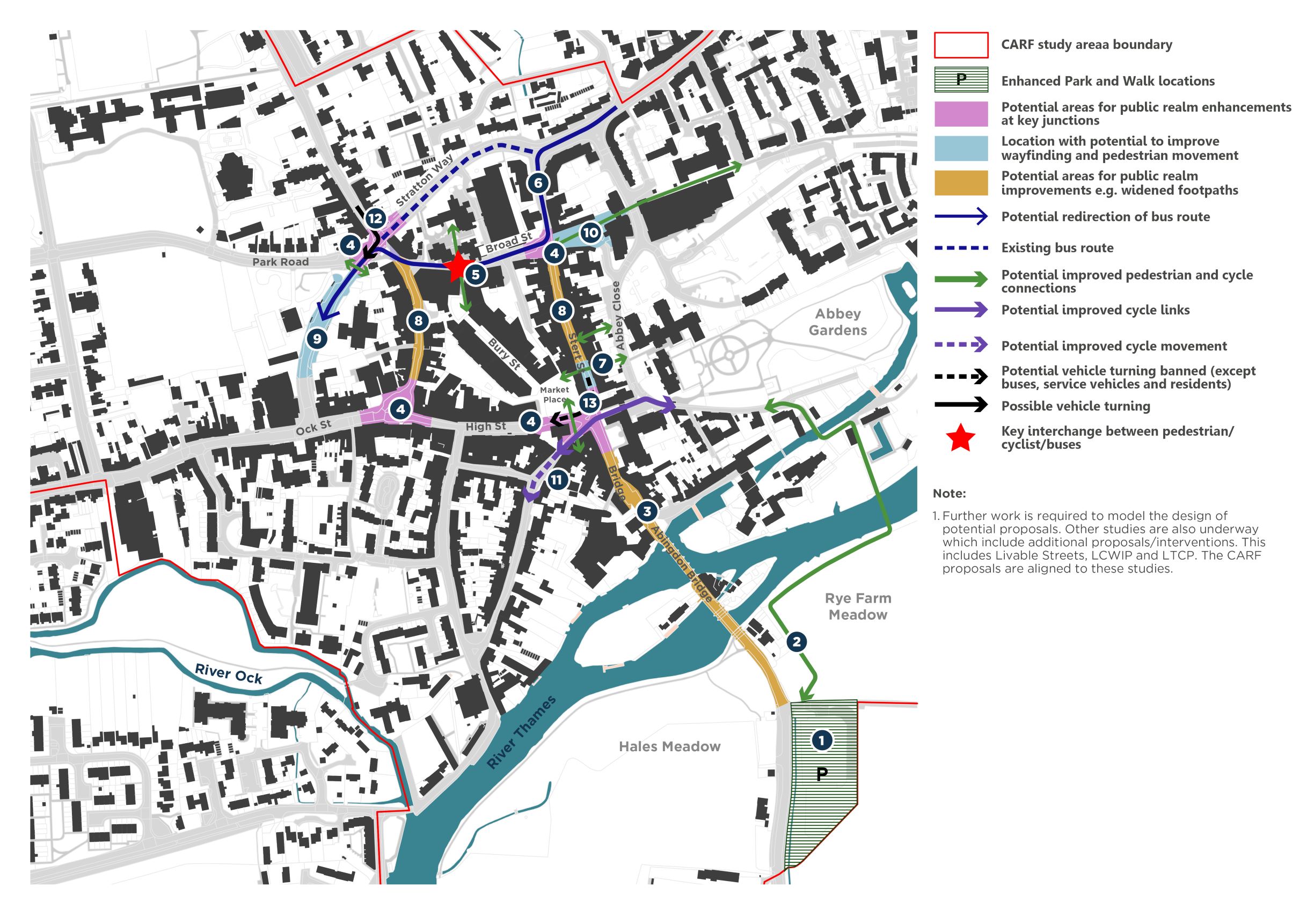
The general aims of the CARF are to enhance the town centre environment for pedestrians, cyclists and public transport users, while reducing the dominance of private vehicle movements. This could be achieved through a variety of potential measures including provision of improved public realm, better signage, increased cycle parking provision, changes to traffic priorities and better integration of public transport services.
Increased provision of park and walk facilities on the periphery of the town centre may release car parking sites in the heart of the town and discourage car journeys whilst enhancing walking and addressing climate change objectives.
Please click on the image to zoom
Key Public Realm improvements suggested are as follows:
- Rye Farm car park and former coach / lorry park could be reconfigured to increase parking capacity to provide an enhanced ‘park and walk facility’. There is potential to provide electric cycle parking here to allow for quicker onward journeys. There is also potential to re-open the coach park.
- Potential for a new pedestrian and cycle bridge over the River Thames with associated onward connections.
- Widened footways across Abingdon Bridge (where carriageway width allows) to improve pedestrian safety between the town centre and Rye Farm car park.
- Areas in the town centre where traffic calming / public realm improvements could be implemented such as raised surfaces or surface materials e.g. block paving to give greater emphasis to pedestrians / cyclists and reducing car dominance.
- Proposed location for a mobility hub at the top of Bury Street and The Charter – an interchange between buses, pedestrians and cyclists.
- Potential to divert southbound buses through Broad Street to bring them closer to the heart of the town centre. This could also become the main servicing route for redeveloped Charter and north end of Bury Street. *Note – northbound buses cannot be diverted along this route as the section of Stert Street between the junction of Broad Street and Vineyard is too narrow to accommodate two-way vehicle flow.
- Existing pedestrian links could be emphasised between Stert Street and Abbey Close.
- Potential to remove on-street parking along Stert Street and Bath Street (southern end) and widen footways, provide enhanced cycle lanes and improve public realm / materials choice to reduce car dominance.
- Potential to improve the public realm experience around the bus stops on Stratton Way and improve signage to and from the town centre.
- Public realm improvements via Old Station Yard to emphasise connectivity between Waitrose and the town centre.
- Contraflow cycle lane from Lombard Street to the junction of Bridge Street / High Street / Stert Street as currently cyclists have to dismount.
- Allow right turns out of Bath Street to reduce traffic having to traverse the gyratory system in order to travel westbound – minimises traffic passing Market Place.
- Ban right-turns from Stert Street to High Street (except for buses, service vehicles and residents) to force traffic to use Stratton Way and thus minimise traffic passing Market Place.
You can continue to explore the consultation materials using the arrows above or the links below.
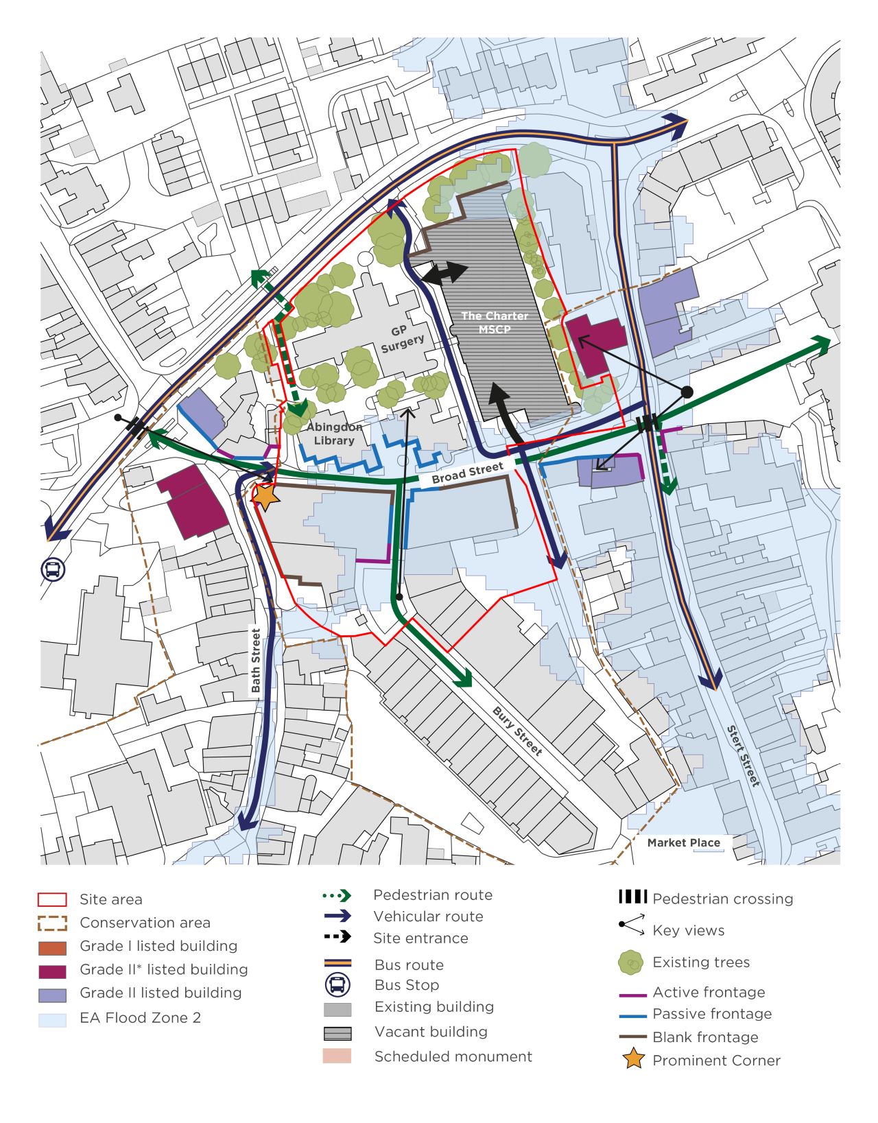
Sites 1 and 2: The Charter and Bury Street North
The Charter and the neighbouring Bury Street North sites are located at the northern edge of Abingdon town centre adjacent to the Abingdon Town Centre Conservation Area. Broad Street, a key east-west link through the town divides the two sites and currently provides access to The Charter car park. Access is provided for vehicles directly onto Stratton Way to the north. Buildings vary between 2-4 storeys in height across the two sites.
Please click on the image to zoom
Opportunities
There is potential to:
- Redevelop both sites to create a major new mixed-use development. This may include restaurants, shops, new housing (including later living homes), a health hub, potential employment/office space and a new public library/tourist information centre to replace the existing facilities.
- Enhance the public realm along Broad Street and Bury Street and provide a new public square at the entrance to The Charter. This new public square could support a new multi-modal transport hub with space for cycle parking/facilities.
- Open up a through route for buses along Broad Street, onto Bath Street connecting with Stratton Way, with a drop-off at The Charter/Bury Street North. This would also serve to relieve the existing congestion along Stert Street.
- Create new accessible green space by retaining existing trees around the site and creating an improved urban park setting.
Constraints
- Abingdon Library facilities may need to be re-provided on the site or relocated elsewhere, however the future of library provision is to be determined by OCC.
- The north-east corner of the site is located within Flood Zone 2.
- There are likely to be a number of ownerships and occupational interests to consider.
- New development would need to consider the impact of views to / from the east towards listed buildings at Stert Street.
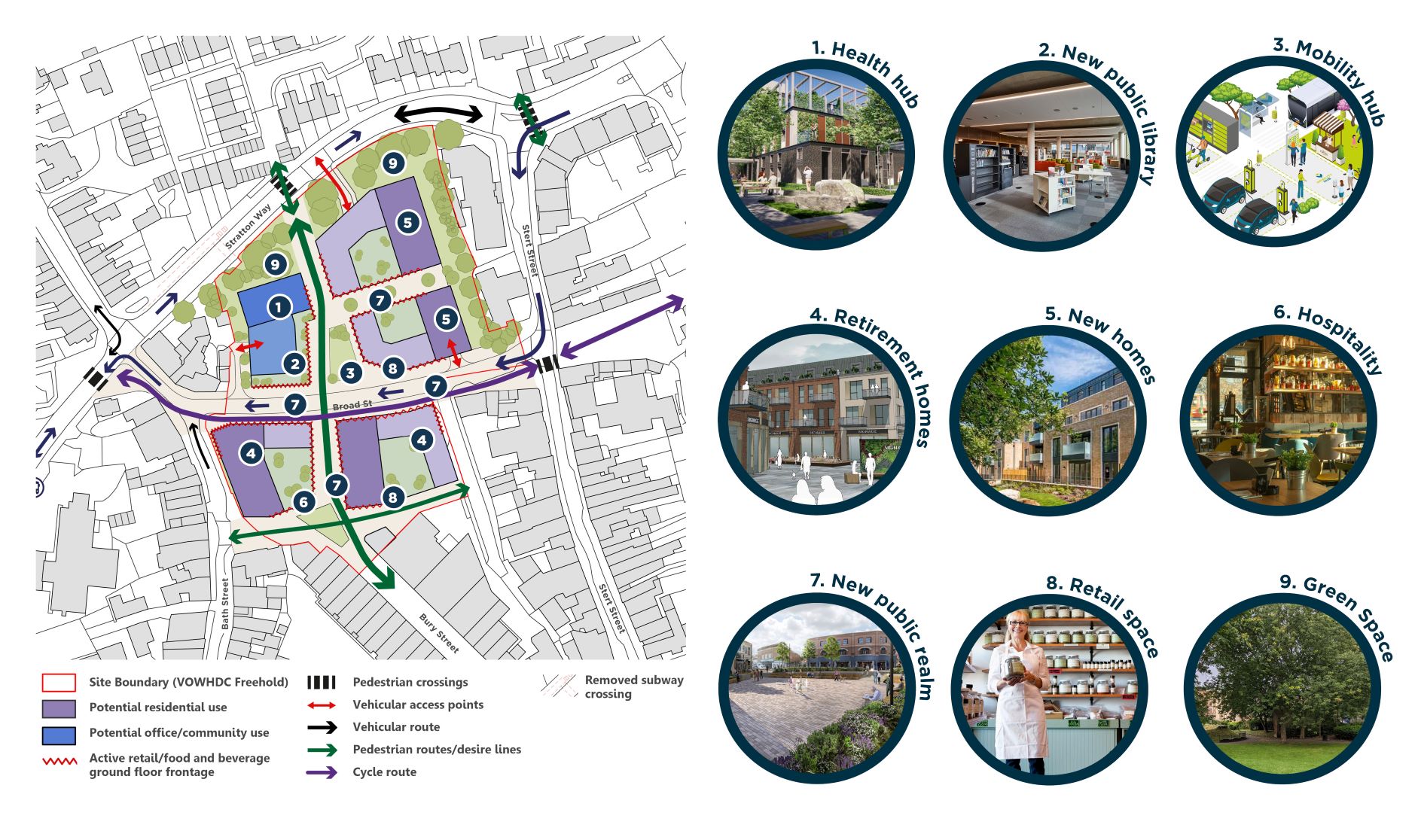
Potential Regeneration Proposals
In order to improve the character, safety and appearance of the area as well as attract people to visit this part of the town centre, there is potential for a comprehensive redevelopment of The Charter and Bury Street North in order to create a new, mixed-use quarter. This area could support a re-provided library with an all-in-one public service hub including a tourist office and other public services.
An integrated health hub could be part of the redevelopment together with ground floor retail and hospitality uses along Bury Street and Broad Street, improving footfall and activity within the area.
New buildings could be 4 or 5 storeys in height supporting residential uses at upper floors with views south over the town, including affordable, starter and later living homes.
Please click on the image to zoom
You can continue to explore the consultation materials using the arrows above or the links below.
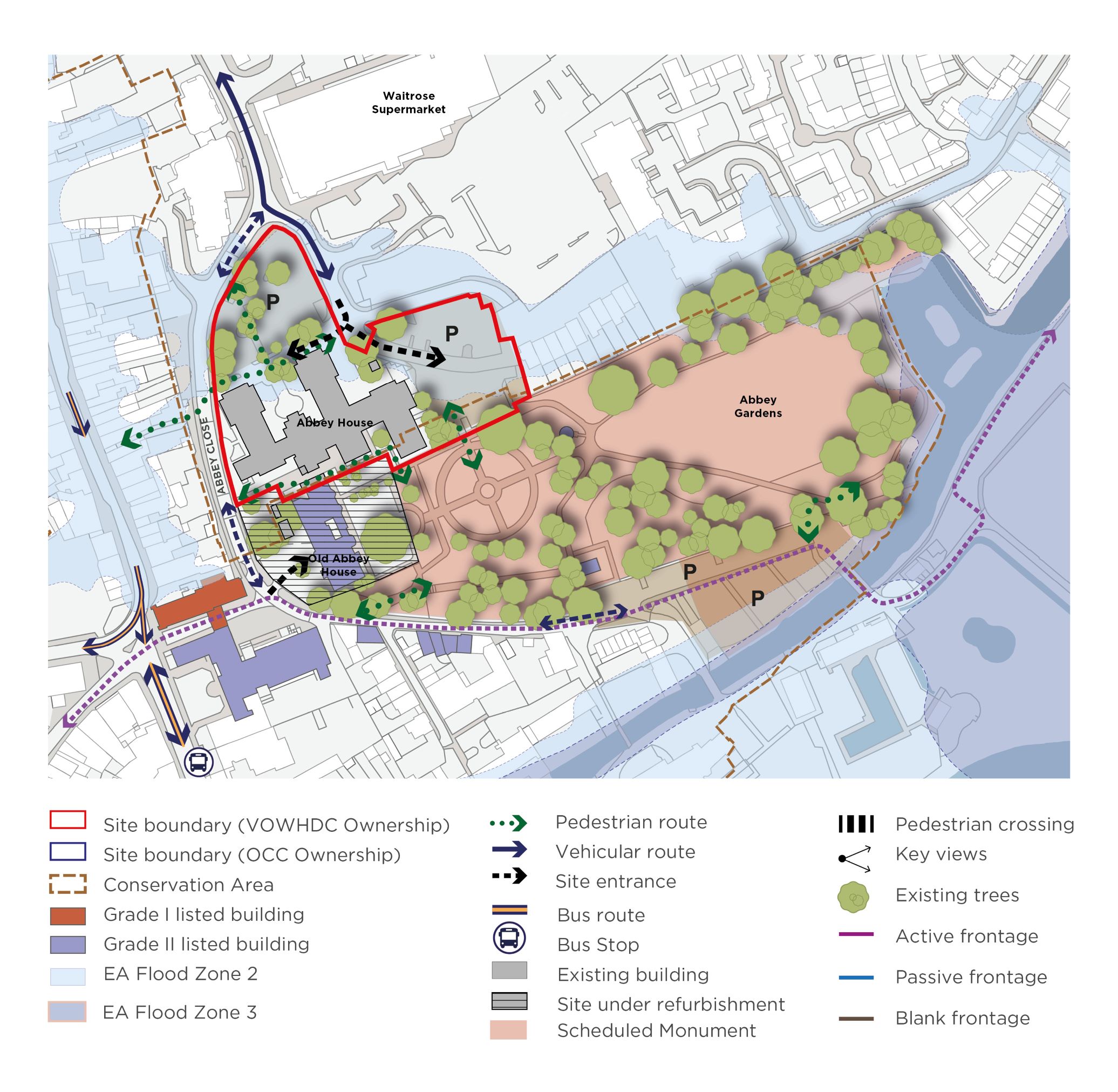
Site 3: Abbey House
Abbey House is located to the eastern edge of Abingdon town centre adjacent to Waitrose supermarket and Abbey Gardens, a Scheduled Monument bounding the site to the south-west. The neighbouring Grade II listed Old Abbey House has current planning permission for the refurbishment of the existing building into a boutique hotel. Parking is provided to the north and east, with the main building access facing north onto the existing car park. The building is three storeys high and is currently used as offices.
Please click on the image to zoom
Opportunities
There is potential to:
- Refurbish and re-purpose the Abbey House building and associated car parking areas to the north and east of the main building.
- Provide a new use which contributes positively to the town centre and complements the neighbouring Old Abbey House. Opportunities include a mixed-use building comprising potential uses that contribute positively to the town centre including office space, residential accommodation, a hotel, a health hub and other community uses.
- Consolidate car parking and provide an improved public realm with pedestrians as a priority, including improvements to pedestrian connections from Stert Street to Abbey Gardens and the neighbouring Waitrose site.
Constraints
- There are likely to be a number of ownerships and occupational interests to consider.
- Any future uses of Abbey House should be sensitive to the adjacent Grade II Listed Old Abbey House and other adjacent Grade I and II listed buildings.
- Any future uses of Abbey House should be sensitive to the Abbey Gardens Scheduled Monument and Abingdon Town Centre Conservation Area.
- Abbey Close is a narrow two-way street leading to the Abbey Close car park, where there is no through route.
Potential Regeneration Proposals
Abbey House has potential for a range of new uses including office space, residential accommodation, a hotel, a health hub and other community uses.
The building may be suitable for conversion given its relatively recent age and availability of car parking which could serve future uses. Improving connections west to Stert Street should also be part of any future proposal. Alternatively, the existing building could be demolished and redeveloped, however this would be subject to confirmation of no alternative viable use for the current building.
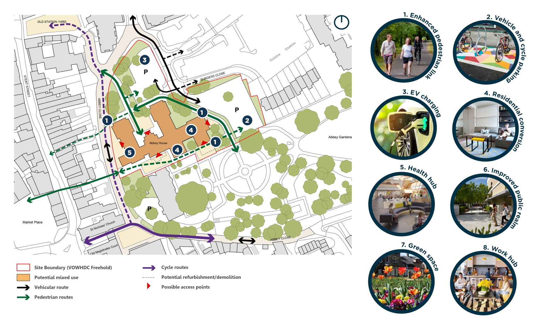
Please click on the image to zoom
You can continue to explore the consultation materials using the arrows above or the links below.
Site 4: Upper Reaches
The freehold of the Upper Reaches site is held by VoWHDC, however the site is subject to a long term lease agreement to a private third party. The 0.45 ha site is home to a Grade II listed building and a more recent unlisted extension which has fallen into disrepair. Future proposals will need to consider these issues, along with the wider heritage setting, key views from Abingdon Bridge, flood risk and access, all of which makes regeneration of the site complex.
Please click on the image to zoom
Opportunities
There is potential to:
- Provide improved pedestrian access into the site using the existing bridge connections from Thames Street.
- Improve views of the river frontage from Abingdon Bridge and from Rye Farm Meadow located to the south of the River Thames.
- Redevelop part of the site and re-purpose the Grade II listed building to the north-east to potentially provide uses such as a hotel and function space, restaurant and other leisure uses, and possibly new homes.
- Provide recreational open space on part of the site that could complement the potential redevelopment of the listed building and any new uses.
Constraints
- The majority of the site lies within Flood Zone 2 and partially in Flood Zone 3, which could limit potential development on the site, or at least part of the site.
- The site falls within the Abingdon Town Centre Conservation Area and there are several listed buildings neighbouring the site’s boundary that may impact development.
- There is a Grade II listed building within the site area that would need to be retained and re-purposed.
- The site is bounded on three sides by the River Thames. If the site were to flood, there could be potential access issues.
- Under the current lease agreement, redevelopment will need to be delivered by the long leaseholder in partnership with VoWHDC.
- Vehicular access onto the site may be limited by the narrow width of the bridge crossing. Thames Street is also very narrow towards it’s eastern end.
Potential Regeneration Proposals
Many people have noted that the Upper Reaches site needs to be redeveloped in order to improve the arrival experience into the town centre from the south at this gateway location. Redevelopment of the site could consider uses such as a hotel and restaurant, function space and other leisure uses, and potentially new homes.
Public access should be delivered as part of any future redevelopment proposal, allowing access for pedestrians to enjoy the River Thames and providing new publicly accessible green space.
Heritage and conservation requirements, including the setting of listed buildings within the Conservation Area, will be key to the success of any future redevelopment or refurbishment proposals.
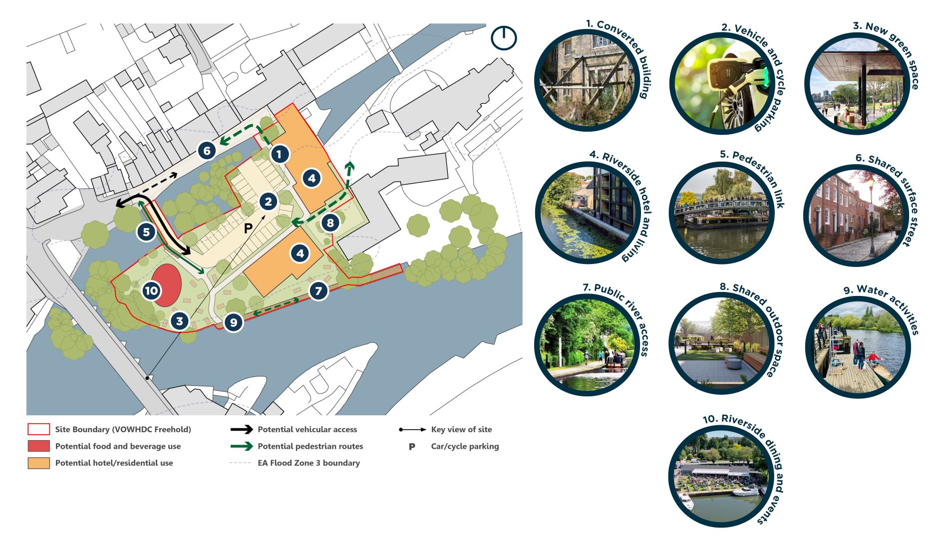
Please click on the image to zoom
You can continue to explore the consultation materials using the arrows above or the links below.
Other Potential Opportunities
Coxeter House and The Net Youth Centre
The Net and Coxeter House sites occupy two adjacent corner plots at a gateway location west of the town centre, both are accessed directly from Stratton Way. The sites are in prominent locations, in particular Coxeter House, with key elevations/aspects onto Stratton Way and Ock Street. The Net site is 0.57 ha and the freehold is held by OCC. The Coxeter House site is 0.45 ha and is under third party ownership.
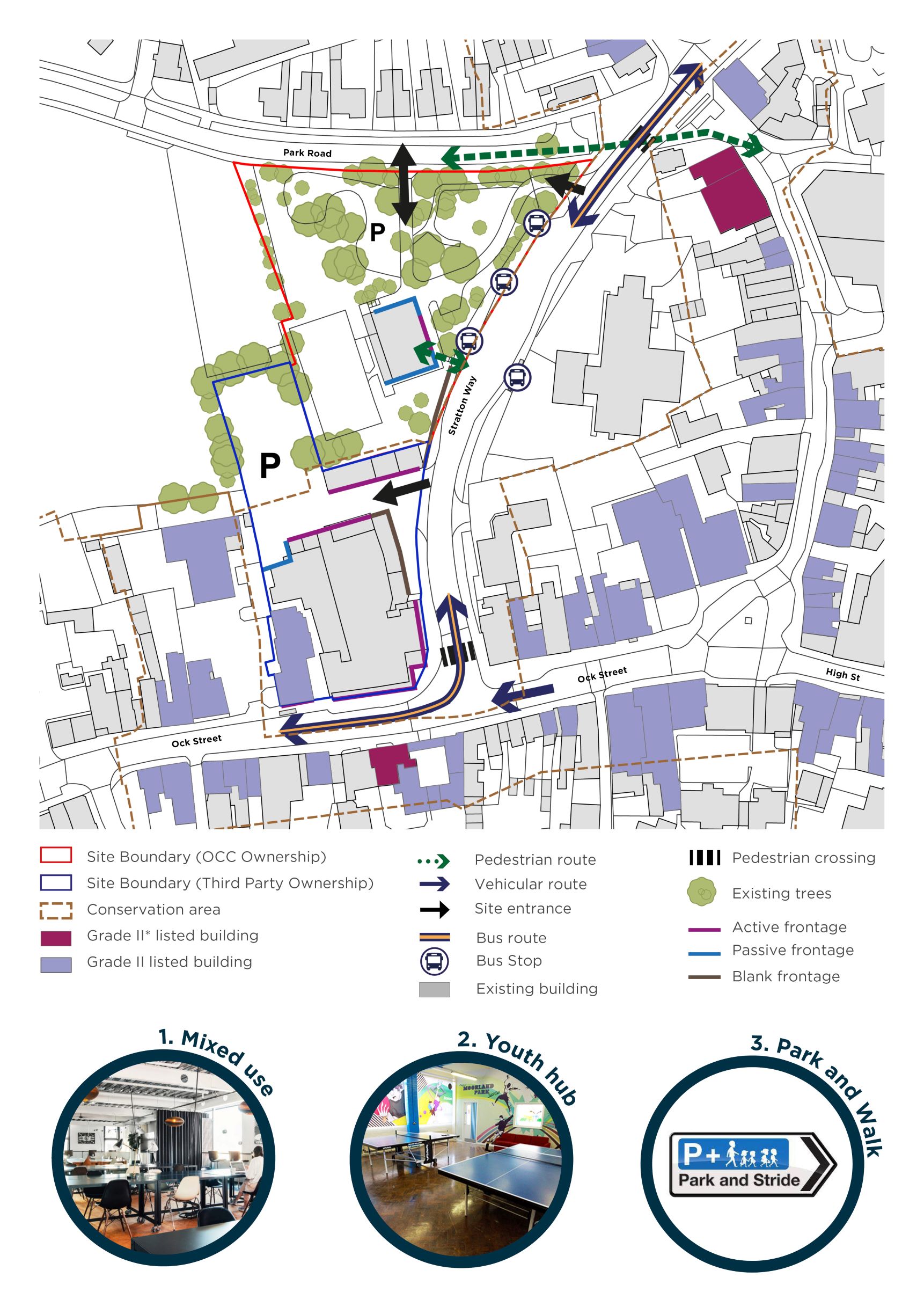
Please click on the image to zoom
Opportunities
There is potential to:
- Create an improved streetscape environment around the northbound bus stops which are located along Stratton Way adjacent to The Net site.
- Improve connections to the east and the wider town centre.
- Consider whether these sites could form part of the Park and Walk strategy for the town centre, capturing traffic from the west.
- Consider new or redevelopment opportunities at either site with a view to increasing site density, including building heights.
- Provide new education and youth facilities.
Constraints
- The sites are under different ownership and not within the control of VoWHDC, therefore any future change would be at the behest of each landowner.
- Acknowledging the presence of established business tenants and ensuring their ongoing operation on site or elsewhere in the town is a key consideration.
- The Net site supports significant areas of open space, including mature trees. There are also neighbouring residents to the north, along with Abingdon School.
You can continue to explore the consultation materials using the arrows above or the links below.